Croatia · Terrestrial
Biokovo Nature Park
Nature park of 19,331 hectares in Croatia, established in 1981.
Overview
Nature park of 19,331 hectares in Croatia, established in 1981.
Biokovo Nature Park is located in Croatia (Europe). It is a predominantly terrestrial area. Established in 1981, it covers about 19,331 hectares.
Protections and designations
Natura 2000 · habitats (SAC) · 2 sites
- Biokovo HR5000030
- Podbiokovlje HR2001350
Natura 2000 · birds (SPA)
- Biokovo i Rilić HR1000030
Protected as a nature park. International labels and designations: Natura 2000 network (3 sites). Key dates: established in 1981, first Natura 2000 site under the Birds Directive in 2013 and first Natura 2000 site under the Habitats Directive in 2014.
In our collections
Timeline
-
1981
Established
-
2013
First Natura 2000 site under the Birds Directive
-
2014
First Natura 2000 site under the Habitats Directive 2 such sites designated up to 2014
Sources: Wikidata (CC0) for establishment and international labels; EEA Natura 2000 database (CC-BY 4.0) for site designation dates.
Frequently asked questions
Where is Biokovo Nature Park?
In Croatia (Europe). Representative point: 43.3294° N, 17.0620° E.
How large is Biokovo Nature Park?
About 19,331 hectares (193 km²). It is the 9th largest of the 13 nature parks in Croatia covered by Parkavela.
When was Biokovo Nature Park established?
In 1981.
What habitats and landscapes does Biokovo Nature Park include?
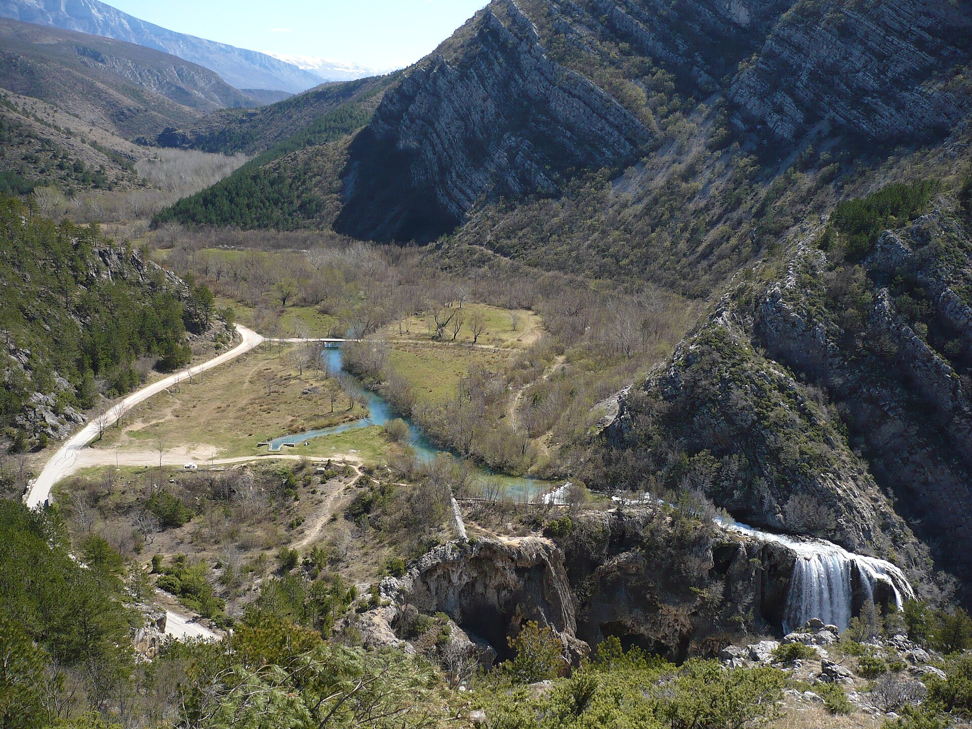
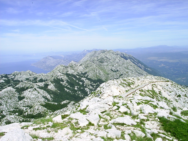
A terrestrial area, with forests and mountains.
What is the highest point of Biokovo Nature Park?
Sveti Jure, at 1,762 m (OpenStreetMap).
What are the main summits of Biokovo Nature Park?
Sveti Jure (1,762 m), Veliki Troglav (1,658 m), Sveti Ilija (1,642 m), Šćirovac (1,619 m) and Ledenica (1,589 m) (OpenStreetMap).
Which international labels apply to Biokovo Nature Park?
Natura 2000 network (3 sites).
When is the best time to visit Biokovo Nature Park?
Best time to visit: from June to September, with average temperatures of 12 to 17 °C and moderate rainfall.
What is there to see in Biokovo Nature Park?
3 caves, including Gradska Spila, Manastirina and Jama Amfora (Wikidata).
Can you swim in Biokovo Nature Park?
One monitored bathing site lies in or within 1 km of the site; official 2025 classification: 1 excellent (European Environment Agency). Swimming is only permitted at the sites and times authorised locally.
What is the nearest large city to Biokovo Nature Park?
Nearest towns of over 50,000 people, as the crow flies: Split (39 km). Nearest airport: Saint Jerome (SPU), about 51 km away.
Where can I get visitor information on site?
Info-Center Park Prirode Biokovo, Mariva and Tourist Bord Muncipal.
Are there waymarked hiking trails in Biokovo Nature Park?
Yes. Waymarked hiking routes listed in OpenStreetMap: 17, including Makarska. The “Makarska - Vošac” route runs for about 6 km through the site, with some 1,050 m of ascent on its longest section.
Which species can be seen in Biokovo Nature Park?
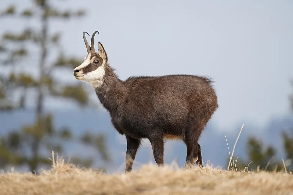
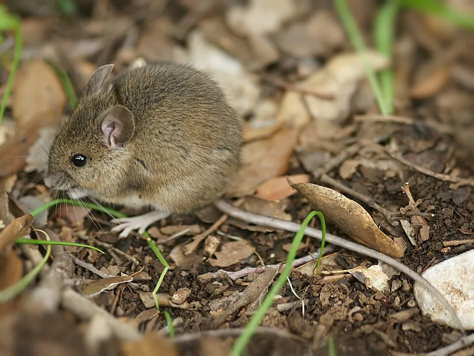
Among the species most often recorded on GBIF are Rupicapra rupicapra (Chamois), Apodemus sylvaticus (Wood mouse), Pyrrhocorax graculus (Alpine Chough) and Kryptonesticus deelemanae.
© OpenStreetMap
Download the boundary: GeoJSON · GPX Boundary © OpenStreetMap contributors (ODbL).
Geography
The representative point of the site lies at around 1,373 m above sea level. Over the 1996–2025 period, the mean annual temperature is about 6.9 °C and total precipitation reaches roughly 1,439 mm per year. The warmest month is usually August, the coolest January, and the wettest November.
Area
- Area
- 19,331 ha
- Elevation
- 1,373 m
- Median elevation
- 915 m
- Mean slope
- 20°
- Coordinates
- 43.3294, 17.062
Terrain: Mapzen Terrain Tiles (SRTM, USGS)
Elevation bands
- below 500 m 19%
- 500–1,000 m 38%
- 1,000–1,500 m 41%
- 1,500–2,000 m 2%
share of the site in each elevation band (smoothed terrain model: summits are rounded off) · Terrain: Mapzen Terrain Tiles (SRTM, USGS)
Main summits
- Sveti Jure1,762 m
- Veliki Troglav1,658 m
- Sveti Ilija1,642 m
- Šćirovac1,619 m
- Ledenica1,589 m
- Ćorlina1,583 m
- Zec1,578 m
- Sedmina1,563 m
- Korenik1,556 m
- Seveljev brig1,549 m
Data © OpenStreetMap contributors (ODbL)
Climate
● Mean temperature (°C) · ▮ Precipitation (mm)
Source: Copernicus ERA5-Land (C3S, doi:10.24381/cds.68d2bb30), monthly averages 1996–2025 interpolated to the representative point, temperatures adjusted for elevation.
Contains modified Copernicus Climate Change Service information 2026. Neither the European Commission nor ECMWF is responsible for any use that may be made of the Copernicus information or data it contains.
Snow cover measured by satellite
J
F
M
A
M
J
J
A
S
O
N
D
average share of the site under snow · snowiest parts · ≈ 10 days a year
Snow cover: MODIS/Terra MOD10CM v61 (Hall & Riggs, 2021, NASA NSIDC DAAC, doi:10.5067/MODIS/MOD10CM.061), imagery from NASA GIBS (ESDIS); 2015–2025 average, grid of about 5 km.
Natural habitats
According to CORINE Land Cover (2018), the site is mainly made up of forests (49%), heath and scrub (18%) and grassland and meadows (15%). Woodland is mostly broadleaved. Elevation ranges from about 240 m to 1,762 m (highest point: Sveti Jure). Median elevation is 915 m, and 43% of the site lies above 1,000 m (SRTM elevation model). The terrain is steep: 21% of slopes exceed 30° (mean slope 20°).
Biodiversity
Based on occurrences aggregated by GBIF, several species are regularly recorded within the site. Among the most frequent are Rupicapra rupicapra (Chamois), Apodemus sylvaticus (Wood mouse), Pyrrhocorax graculus (Alpine Chough) and Kryptonesticus deelemanae. The full list of documented taxa is shown below. The overlapping Natura 2000 sites list 32 species of European interest: 16 birds, 6 mammals, 2 reptiles, 1 amphibian, 6 invertebrates and 1 plant.
Species of European interest
Birds · 16
Rock Partridge (Alectoris graeca) resident, Tawny Pipit (Anthus campestris) breeding, Golden Eagle (Aquila chrysaetos) resident, Eurasian Eagle-owl (Bubo bubo) resident, European Nightjar (Caprimulgus europaeus) breeding, Short-toed Snake Eagle (Circaetus gallicus) breeding, Hen Harrier (Circus cyaneus) wintering, White-backed Woodpecker (Dendrocopos leucotos) resident, Black Woodpecker (Dryocopus martius) resident, Ortolan Bunting (Emberiza hortulana) breeding, Peregrine Falcon (Falco peregrinus) resident, Common Crane (Grus grus) passage and 4 more
Mammals · 6
Grey wolf (Canis lupus), Balkan snow vole (Dinaromys bogdanovi), Common bent-wing bat (Miniopterus schreibersii), Bechstein's bat (Myotis bechsteinii), Greater Horseshoe Bat (Rhinolophus ferrumequinum), Lesser horseshoe bat (Rhinolophus hipposideros)
Reptiles · 2
Mosor rock lizard (Dinarolacerta mosorensis), European ratsnake (Zamenis situla)
Amphibians · 1
Invertebrates · 6
Greater Capricorn Beetle (Cerambyx cerdo), Jersey Tiger (Euplagia quadripunctaria), Stag beetle (Lucanus cervus), Morimus asper funereus, Dalmatian Ringlet (Proterebia afra dalmata), Rosalia longicorn (Rosalia alpina)
Plants · 1
Scopoli's Rockcress (Arabis scopoliana)
Source: Natura 2000 standard data forms (EEA, CC-BY 4.0). Not exhaustive: sensitive species are not published.
Species to look out for
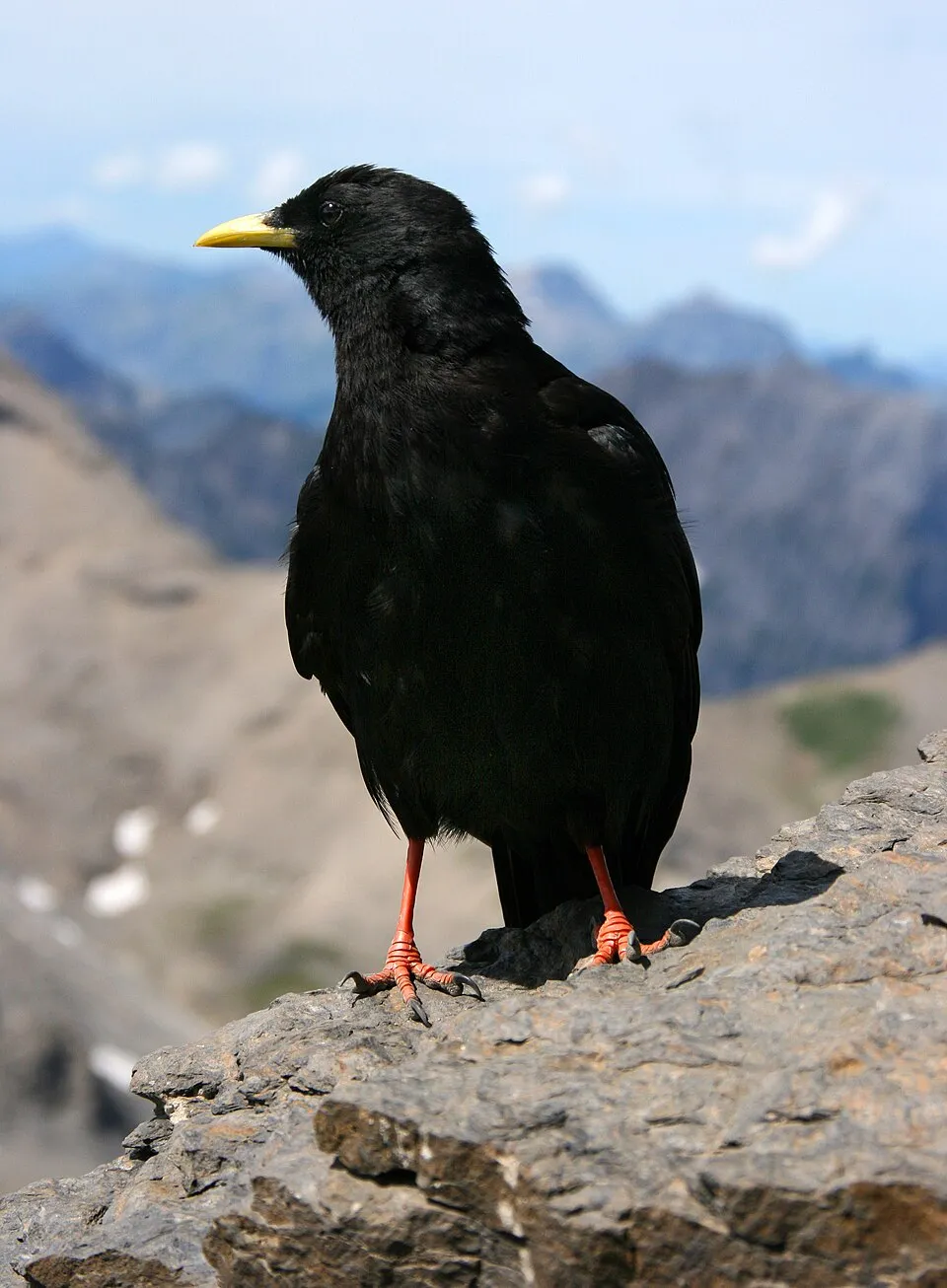



Observed species
Occurrences documented via GBIF; they are neither an exhaustive inventory nor proof of current presence.
- Chamois · Rupicapra rupicapra · 112
- Wood mouse · Apodemus sylvaticus · 110
- Alpine Chough · Pyrrhocorax graculus · 70
- Kryptonesticus deelemanae · 70
- Savi's Pipistrelle · Hypsugo savii · 56
- Stygopholcus absoloni · 55
- Eurasian Chaffinch · Fringilla coelebs · 52
- Speoplanes giganteus · 52
- Common Kestrel · Falco tinnunculus · 41
- Common Chiffchaff · Phylloscopus collybita · 40
- Black Redstart · Phoenicurus ochruros · 39
- Histopona conveniens · 36
Records: GBIF.org (CC-BY). Names: Wikidata (CC0), GBIF. Photos: Wikimedia Commons.
Conservation challenges
The primary purpose of the site is to preserve its natural habitats and the biodiversity they support. The species recorded (Biodiversity tab) reflect its ecological value. The designations it holds frame its management and the control of land use.
According to Global Forest Change data (University of Maryland, Global Forest Watch), about 119 ha of tree cover were lost within the boundary between 2001 and 2023 (under 1% of its area), peaking in 2017 and 2023. These losses include logging, storms and fires, and do not account for regrowth. According to the European CORINE Land Cover inventory (Copernicus), land cover changed on about 145 ha of the site between 1990 and 2018 (under 1% of its area): forest shrank by 131 ha, mostly giving way to open natural land. Since 2016, the European EFFIS system (Copernicus) has mapped 6 fires here, burning about 1,962 ha within the boundary; the largest, in August 2017 (near Baška Voda), covered 922 ha. At night, 6% of the area gives off artificial light detectable from space (NASA VIIRS Black Marble composite, 2016). According to the Water Framework Directive assessment (2022 river basin management plans, data 2016–2019), the only river assessed within the site has high ecological status.
Pressure indicators
Tree cover lost
119 ha
2001–2023 · < 1% of the area
20012023
Fires since 2016
1,962 ha
burned within the boundary (6 mapped fires)
- 2017 · Baška Voda · 922 ha
- 2024 · Tučepi · 873 ha
- 2017 · Podgora · 83 ha
Light at night
6%
of the area gives off artificial light visible from space
DarkLit
Built-up land
< 1%
buildings, business areas, roads, quarries · farmland 2%
Land cover change
145 ha
changed cover, 1990–2018 · CORINE · < 1% of the area
- −131 ha · forest
Rivers and lakes
100%
of the 5 km of assessed rivers in good or high ecological status · WFD 2022
assessments 2016–2019
Sources: Global Forest Change (Hansen et al., University of Maryland, via Global Forest Watch, CC-BY 4.0); EFFIS, European Commission / Copernicus; NASA Black Marble 2016 (public domain); CORINE Land Cover 2018 (Copernicus) or MODIS.
CORINE Land Cover Change 1990–2018: generated using European Union's Copernicus Land Monitoring Service information (EEA), aggregated by Parkavela; DOI 10.2909/f30f1000-7cf8-43bb-872c-5eb093911b24.
Ecological status of water bodies: European Environment Agency, WISE – Water Framework Directive, 3rd river basin management plans (2022), CC BY 4.0. Official national classification, not comparable between countries.
Practical information
Cities and airport
- Split
39 km as the crow flies - Airport: Saint Jerome (SPU)
51 km as the crow flies
Visitor information
- Info-Center Park Prirode Biokovo
within the site - Mariva
1 km from the site boundary - Tourist Bord Muncipal
1 km from the site boundary - Tourist agency
1 km from the site boundary
Hiking
17 waymarked routes listed, including:
Makarska
Trail difficulty
- T1 · easy hiking · 10% · 17 km
- T2 · mountain hiking · 40% · 63 km
- T3–T6 · demanding or alpine hiking · 45% · 69 km
149 km graded out of 186 km of paths
SAC scale (T1–T6) © OpenStreetMap contributors (ODbL): indicative only, check with the park.
By bike
N1 Nacionalna ruta N1 · 2 km
+ 6 local loops
Signed cycle routes: this does not mean that cycling is allowed on footpaths.
Data © OpenStreetMap contributors (ODbL) · Wikidata (CC0)
Routes © OpenStreetMap contributors (ODbL), via Waymarked Trails
Waymarked hiking routes
Makarska - Vošac
5.5 km within the site ↗ 1,054 m↘ 28 m 266–1,328 m
up to T3 · demanding mountain hiking
Srida Selo-M-Lađena
4.1 km within the site ↗ 19 m↘ 908 m 360–1,258 m
up to T3 · demanding mountain hiking
Turići-pl.dom Lađena
11.1 km within the site ↗ 108 m↘ 765 m 624–1,391 m
up to T3 · demanding mountain hiking
Tracks © OpenStreetMap contributors (ODbL), clipped to the boundary; elevation gain and profiles computed on the longest section from Mapzen Terrain Tiles (≈ 30 m), indicative only. Indicative difficulty (SAC scale, OpenStreetMap, via Waymarked Trails): check with the park.
Bathing
1 monitored bathing site in or within 1 km of the site · 2025 classification
Excellent · 1
- Stomarica · sea · Excellent
Source: European Environment Agency, official bathing water classification (Directive 2006/7/EC, CC-BY 4.0). Swimming is only permitted at the sites and times authorised locally.
Access and visiting
Nearest towns of over 50,000 people, as the crow flies: Split (39 km). Nearest airport: Saint Jerome (SPU), about 51 km away. About 99,000 people live within 20 km of the site boundary, 39,000 of them within 10 km; some 1,300 people are estimated to live inside (GHSL estimate, 2020). This population has fallen by about 14% since 2000. Visitor information on site: Info-Center Park Prirode Biokovo, Mariva and Tourist Bord Muncipal. Waymarked hiking routes listed in OpenStreetMap: 17, including Makarska. Of the roughly 150 km of paths with a difficulty grade in OpenStreetMap, 10% are easy hiking (T1), 40% mountain hiking (T2) and 45% demanding or alpine hiking (T3–T6). This is indicative only: check with the park. A signed cycle route crosses the site: “N1 Nacionalna ruta N1” (OpenStreetMap). To see: 3 caves, including Gradska Spila, Manastirina and Jama Amfora. To plan a visit (access, opening periods, visitor rules), it is best to consult the official information from the managing body and the official website listed in this page's sources.
Source: OpenStreetMap (ODbL), Wikidata (CC0), October 2026.
When to visit
Best time to visit: from June to September, with average temperatures of 12 to 17 °C and moderate rainfall. Average temperatures drop below 0 °C from December to February: frost is common. Precipitation peaks in November (up to 230 mm per month). These averages apply to the site's representative point (1,373 m); higher up it is markedly cooler and snow lasts longer. Snow only makes brief appearances in winter (about 10 days a year on average, MODIS satellites 2015–2025). Day length ranges from about 8 h 59 min in December to 15 h 23 min in June. Wildlife records published on GBIF peak for birds (June), plants (May and June), butterflies and moths (May and June) and mammals (July). These peaks also reflect when observers are most active.
Source: Copernicus ERA5-Land (C3S), monthly averages 1996–2025 at the representative point, temperatures adjusted for elevation.
Contains modified Copernicus Climate Change Service information 2026. Neither the European Commission nor ECMWF is responsible for any use that may be made of the Copernicus information or data it contains.
Wildlife records calendar
JFMAMJJASOND
Birds
Plants
Butterflies & moths
Mammals
Monthly records published on GBIF (CC-BY), relative to the busiest month; also reflects observer activity.
Gallery
© Martin Brož · CC BY 3.0
© Aleksandar Topuzović · CC BY 3.0
© Breta Valek from Czech Republic · CC BY-SA 2.0
© Breta Valek · CC BY-SA 2.0
© kallerna · CC BY-SA 3.0
© d.graso · CC BY 3.0
Sources and licences
- Wikidata: Q13405537
- OpenStreetMap: relation 6889390
- Wikipedia: en.wikipedia.org/wiki/Biokovo_Nature_Park
- WDPA: 20700
References
- cds.climate.copernicus.eu: climate · CC-BY-4.0
- registry.opendata.aws: elevation of the reference point, detailed relief · PD
- land.copernicus.eu: land cover, land cover change, sea share · COPERNICUS
- doi.org: population around the site · CC-BY-4.0
- wikidata.org: official area, establishment date, nearby cities and airport, access and peaks, lake depths, places to see · CC0-1.0
- eea.europa.eu: bathing water quality, ecological status of waters · CC-BY-4.0
- en.eurovelo.com: EuroVelo cycle routes · ODbL-1.0
- cycling.waymarkedtrails.org: cycle routes · ODbL-1.0
- opentopodata.org: elevations · PD
- forest-fire.emergency.copernicus.eu: wildfires · COPERNICUS
- globalforestwatch.org: tree cover loss · CC-BY-4.0
- gbif.org: seasonality of sightings, invasive alien species, observed species · CC-BY-4.0
- hydrosheds.org: lakes · CC-BY-4.0
- natura2000.eea.europa.eu: Natura 2000 habitats and species · CC-BY-4.0
- openstreetmap.org: official name, access and peaks, trail difficulty · ODbL-1.0
- earthobservatory.nasa.gov: night light · PD
- hiking.waymarkedtrails.org: route difficulty · ODbL-1.0
- nsidc.org: snow cover · PD
- wikidata.org: Wikipedia article · CC-BY-SA-4.0
Data © OpenStreetMap contributors (ODbL), Wikidata (CC0) and the sources cited.