Austria · Terrestrial
Mannersdorf-Wüste Nature Park
Nature park of 110 hectares in Austria.
Overview
Nature park of 110 hectares in Austria.
Mannersdorf-Wüste Nature Park is located in Austria (Europe). It is a predominantly terrestrial area. It covers about 110 hectares.
In our collections
Frequently asked questions
Where is Mannersdorf-Wüste Nature Park?
In Austria (Europe). Representative point: 47.9534° N, 16.6002° E.
How large is Mannersdorf-Wüste Nature Park?
About 110 hectares (1 km²). It is the 18th largest of the 21 nature parks in Austria covered by Parkavela.
What habitats and landscapes does Mannersdorf-Wüste Nature Park include?
A terrestrial area, with forests.
What rocks lie beneath Mannersdorf-Wüste Nature Park?
According to the European 1:1 million geological map (EGDI), the bedrock consists mainly of marbles (63% of sampled points). These are mostly metamorphic rocks. The geological units date mainly from the Mesozoic (63% of sampled points).
What is the highest point of Mannersdorf-Wüste Nature Park?
Schlossberg, at 337 m (OpenStreetMap).
When is the best time to visit Mannersdorf-Wüste Nature Park?
Mildest period: from June to August, with average temperatures of 19 to 21 °C.
Are there historic monuments in Mannersdorf-Wüste Nature Park?
Yes. According to Wikidata, 3 monuments listed as protected monuments in Austria stand within the boundary. For example: “Kloster St. Anna in der Wüste” in Mannersdorf am Leithagebirge, “Burg Scharfeneck” in Mannersdorf am Leithagebirge and “Nepomukstatue” in Mannersdorf am Leithagebirge.
What is the nearest large city to Mannersdorf-Wüste Nature Park?
Nearest towns of over 50,000 people, as the crow flies: Sopron (29 km) and Vienna (32 km). Nearest airport: Wien-Schwechat (VIE), about 17 km away.
How can I reach Mannersdorf-Wüste Nature Park by train?
The nearest railway station is Götzendorf an der Leitha, about 7 km from the site boundary.
Are there waymarked hiking trails in Mannersdorf-Wüste Nature Park?
Yes. Waymarked hiking routes listed in OpenStreetMap: 4, including NÖ Landesrundwanderweg.
Which species can be seen in Mannersdorf-Wüste Nature Park?
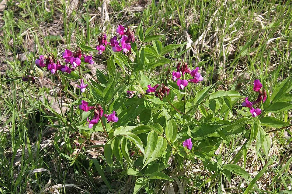
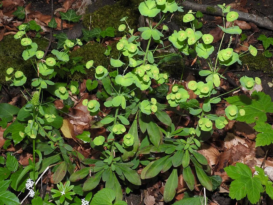
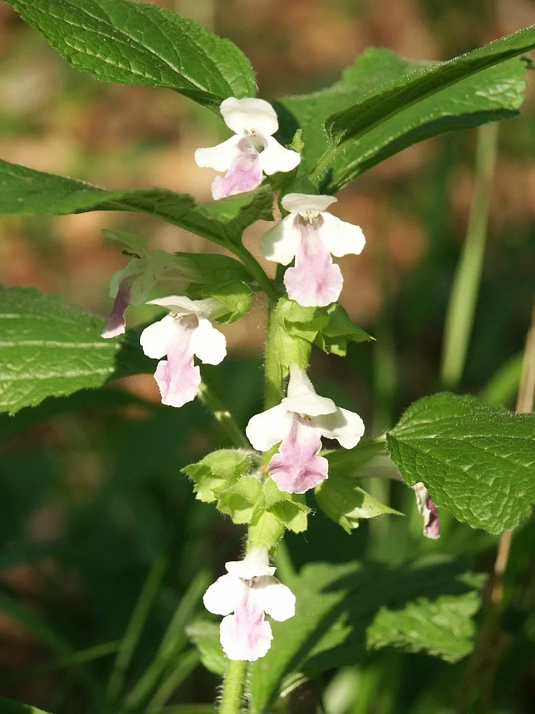
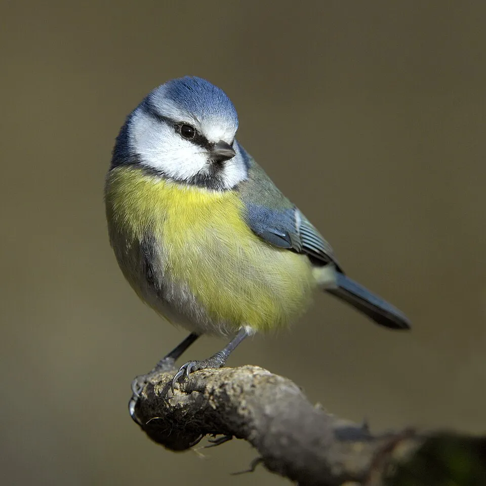
Among the species most often recorded on GBIF are Lathyrus vernus (Spring vetch), Euphorbia amygdaloides (Wood Spurge), Melittis melissophyllum (Bastard Balm) and Cyanistes caeruleus (Eurasian blue tit).
© OpenStreetMap
Download the boundary: GeoJSON · GPX Boundary © OpenStreetMap contributors (ODbL).
Geography
The representative point of the site lies at around 250 m above sea level. Over the 1996–2025 period, the mean annual temperature is about 10.6 °C and total precipitation reaches roughly 672 mm per year. The warmest month is usually July, the coolest January, and the wettest July. According to the European 1:1 million geological map (EGDI), the bedrock consists mainly of marbles (63% of sampled points). These are mostly metamorphic rocks. The geological units date mainly from the Mesozoic (63% of sampled points).
Area
- Area of the boundary
- 110 ha
- Elevation
- 250 m
- Mean slope
- 9°
- Coordinates
- 47.9534, 16.6002
Terrain: Mapzen Terrain Tiles (SRTM, USGS; © offene Daten Österreichs – Digitales Geländemodell (DGM) Österreich, CC BY 3.0 AT)
Bedrock
- Marbles 63 %
- Clastic sedimentary rocks 38 %
Metamorphic rocks 63 % · Sedimentary rocks 38 % · Main age: Mesozoic (63%)
Source: EGDI 1:1M geological map (EuroGeoSurveys and national geological surveys), CC BY 4.0 · 16 sampled points within the site.
Climate
● Mean temperature (°C) · ▮ Precipitation (mm)
Source: Copernicus ERA5-Land (C3S, doi:10.24381/cds.68d2bb30), monthly averages 1996–2025 interpolated to the representative point, temperatures adjusted for elevation.
Contains modified Copernicus Climate Change Service information 2026. Neither the European Commission nor ECMWF is responsible for any use that may be made of the Copernicus information or data it contains.
Snow cover measured by satellite
J
F
M
A
M
J
J
A
S
O
N
D
average share of the area under snow · snowiest parts · ≈ 10 days a year
Snow cover: MODIS/Terra MOD10CM v61 (Hall & Riggs, 2021, NASA NSIDC DAAC, doi:10.5067/MODIS/MOD10CM.061), imagery from NASA GIBS (ESDIS); 2015–2025 average, grid of about 5 km.
Natural habitats
According to CORINE Land Cover (2018), the site is mainly made up of forests (100%). Woodland is mostly broadleaved. Elevation ranges from about 230 m to 337 m (highest point: Schlossberg).
Biodiversity
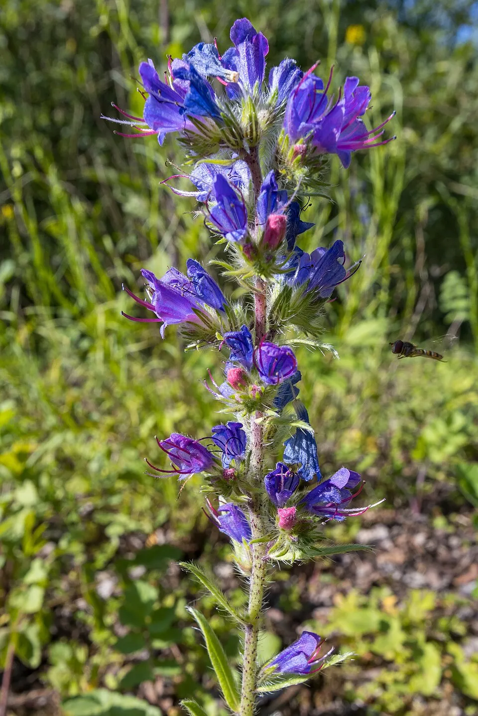
Based on occurrences aggregated by GBIF, several species are regularly recorded within the site. Among the most frequent are Lathyrus vernus (Spring vetch), Euphorbia amygdaloides (Wood Spurge), Melittis melissophyllum (Bastard Balm) and Cyanistes caeruleus (Eurasian blue tit). The full list of documented taxa is shown below.
Species to look out for

Observed species
Occurrences documented via GBIF; they are neither an exhaustive inventory nor proof of current presence.
- Spring vetch · Lathyrus vernus · 8
- Wood Spurge · Euphorbia amygdaloides · 7
- Bastard Balm · Melittis melissophyllum · 7
- Eurasian blue tit · Cyanistes caeruleus · 5
- Viper's Bugloss · Echium vulgare · 5
- Comma · Polygonia c-album · 4
- Great Spotted Woodpecker · Dendrocopos major · 4
- Eurasian Nuthatch · Sitta europaea · 4
- Eurasian Chaffinch · Fringilla coelebs · 4
- Coltsfoot · Tussilago farfara · 4
- Lesser periwinkle · Vinca minor · 4
- Toothwort · Lathraea squamaria · 4
+18 more species
- Eurasian Jay · Garrulus glandarius · 4
- Great tit · Parus major · 4
- Silver-washed fritillary · Argynnis paphia · 3
- Orange-tip · Anthocharis cardamines · 3
- Marsh Tit · Poecile palustris · 3
- Spotted Flycatcher · Muscicapa striata · 3
- Hawfinch · Coccothraustes coccothraustes · 3
- Common Wood Pigeon · Columba palumbus · 3
- Ramsons · Allium ursinum · 3
- Hazel · Corylus avellana · 3
- European Cyclamen · Cyclamen purpurascens · 3
- Purple mullein · Verbascum phoeniceum · 3
- Jersey Tiger · Euplagia quadripunctaria · 3
- Pallas's Sailer · Neptis sappho · 3
- Common toad · Bufo bufo · 3
- Bird-in-a-bush · Corydalis solida · 3
- Common Ivy · Hedera helix · 3
- Middle Spotted Woodpecker · Dendrocoptes medius · 3
Records: GBIF.org (CC-BY). Names: Wikidata (CC0), GBIF. Photos: Wikimedia Commons.
Conservation challenges
The primary purpose of the site is to preserve its natural habitats and the biodiversity they support. The species recorded (Biodiversity tab) reflect its ecological value. Its status as a nature park sets the regulatory framework for its protection.
At night, the area gives off virtually no artificial light detectable from space (NASA VIIRS Black Marble composite, 2016). One invasive alien species has been recorded within the site since 2000 (GBIF observations), listed as of Union concern: Impatiens glandulifera (Himalayan Balsam).
Pressure indicators
Tree cover lost
5 ha
2001–2023
20012023
Fires since 2016
0
No large fire mapped (fires over about 30 ha)
Light at night
0%
of the area gives off artificial light visible from space
DarkLit
Invasive alien species
1
incl. 1 of EU concern · since 2000
Sources: Global Forest Change (Hansen et al., University of Maryland, via Global Forest Watch, CC-BY 4.0); EFFIS, European Commission / Copernicus; NASA Black Marble 2016 (public domain); CORINE Land Cover 2018 (Copernicus) or MODIS.
Invasive alien species: Global Register of Introduced and Invasive Species (ISSG, CC BY 4.0); Union list, Regulation (EU) 1143/2014 (INBO, CC0); GBIF.org records (CC0 / CC BY 4.0), at least 2 per species.
Practical information
Cities and airport
- Sopron
29 km as the crow flies - Vienna
32 km as the crow flies - Airport: Wien-Schwechat (VIE)
17 km as the crow flies
Hiking
4 waymarked routes listed, including:
NÖ Landesrundwanderweg
Data © OpenStreetMap contributors (ODbL) · Wikidata (CC0)
Waymarked hiking routes
blau-gelb Kleiner und Großer Rundwanderweg Mannersdorf
1.5 km within the site ↗ 24 m↘ 22 m 235–265 m
rot Mannersdorf - Kaisereiche - Donnerskirchen
1.5 km within the site ↗ 26 m↘ 23 m 235–265 m
Tracks © OpenStreetMap contributors (ODbL), clipped to the boundary; elevation gain and profiles computed on the longest section from Mapzen Terrain Tiles (≈ 30 m), indicative only.
Access and visiting
The nearest railway station is Götzendorf an der Leitha, about 7 km from the site boundary. Nearest towns of over 50,000 people, as the crow flies: Sopron (29 km) and Vienna (32 km). Nearest airport: Wien-Schwechat (VIE), about 17 km away. About 170,000 people live within 20 km of the site boundary, 28,000 of them within 10 km (GHSL estimate, 2020). This population has grown by about 22% since 2000. Waymarked hiking routes listed in OpenStreetMap: 4, including NÖ Landesrundwanderweg. To plan a visit (access, opening periods, visitor rules), it is best to consult the official information from the managing body and the official website listed in this page's sources.
Source: OpenStreetMap (ODbL), Wikidata (CC0), October 2026.
Built heritage
According to Wikidata, 3 monuments listed as protected monuments in Austria stand within the boundary. Examples include “Kloster St. Anna in der Wüste” in Mannersdorf am Leithagebirge, “Burg Scharfeneck” in Mannersdorf am Leithagebirge and “Nepomukstatue” in Mannersdorf am Leithagebirge.
1 castle or fortification1 religious building
-
Kloster St. Anna in der Wüste
Mannersdorf am Leithagebirge -
Burg Scharfeneck
Mannersdorf am Leithagebirge -
Nepomukstatue
Mannersdorf am Leithagebirge
Source: Wikidata (CC0), monuments in each country’s official heritage protection registers, at national or regional level. Each item links to its Wikidata entry.
When to visit
Mildest period: from June to August, with average temperatures of 19 to 21 °C. Snow only makes brief appearances in winter (about 10 days a year on average, MODIS satellites 2015–2025). Day length ranges from about 8 h 24 min in December to 16 h 01 min in June. Wildlife records published on GBIF peak for plants (April) and butterflies and moths (June). These peaks also reflect when observers are most active.
Source: Copernicus ERA5-Land (C3S), monthly averages 1996–2025 at the representative point, temperatures adjusted for elevation.
Contains modified Copernicus Climate Change Service information 2026. Neither the European Commission nor ECMWF is responsible for any use that may be made of the Copernicus information or data it contains.
Wildlife records calendar
JFMAMJJASOND
Plants
Butterflies & moths
Monthly records published on GBIF (CC-BY), relative to the busiest month; also reflects observer activity.
Gallery
© Roman Klementschitz · CC BY 3.0
© C.Stadler/Bwag · CC BY-SA 4.0
© C.Stadler/Bwag (talk / email) · CC BY-SA 4.0
© Ulrich Latzenhofer from Perchtoldsdorf, Österreich · CC BY-SA 2.0
© Joadl · CC BY-SA 3.0
© Joadl · CC BY-SA 3.0
Sources and licences
- Wikidata: Q1970531
- OpenStreetMap: relation 10541333
- Wikipedia: de.wikipedia.org/wiki/Naturpark_Mannersdorf-Wüste
References
- cds.climate.copernicus.eu: climate · CC-BY-4.0
- registry.opendata.aws: elevation of the reference point, detailed relief · CC-BY-3.0
- land.copernicus.eu: land cover, land cover change, sea share · COPERNICUS
- doi.org: population around the site · CC-BY-4.0
- openstreetmap.org: access and peaks, trail difficulty · ODbL-1.0
- eea.europa.eu: bathing water quality, ecological status of waters · CC-BY-4.0
- en.eurovelo.com: EuroVelo cycle routes · ODbL-1.0
- cycling.waymarkedtrails.org: cycle routes · ODbL-1.0
- opentopodata.org: elevations · PD
- forest-fire.emergency.copernicus.eu: wildfires · COPERNICUS
- globalforestwatch.org: tree cover loss · CC-BY-4.0
- gbif.org: seasonality of sightings, invasive alien species, observed species · CC-BY-4.0
- europe-geology.eu: geology · CC-BY-4.0
- wikidata.org: protected heritage, official name, nearby cities and airport, access and peaks, lake depths, places to see · CC0-1.0
- hydrosheds.org: lakes · CC-BY-4.0
- earthobservatory.nasa.gov: night light · PD
- hiking.waymarkedtrails.org: route difficulty · ODbL-1.0
- nsidc.org: snow cover · PD
- wikidata.org: Wikipedia article · CC-BY-SA-4.0
Data © OpenStreetMap contributors (ODbL), Wikidata (CC0) and the sources cited.