Spain · Terrestrial
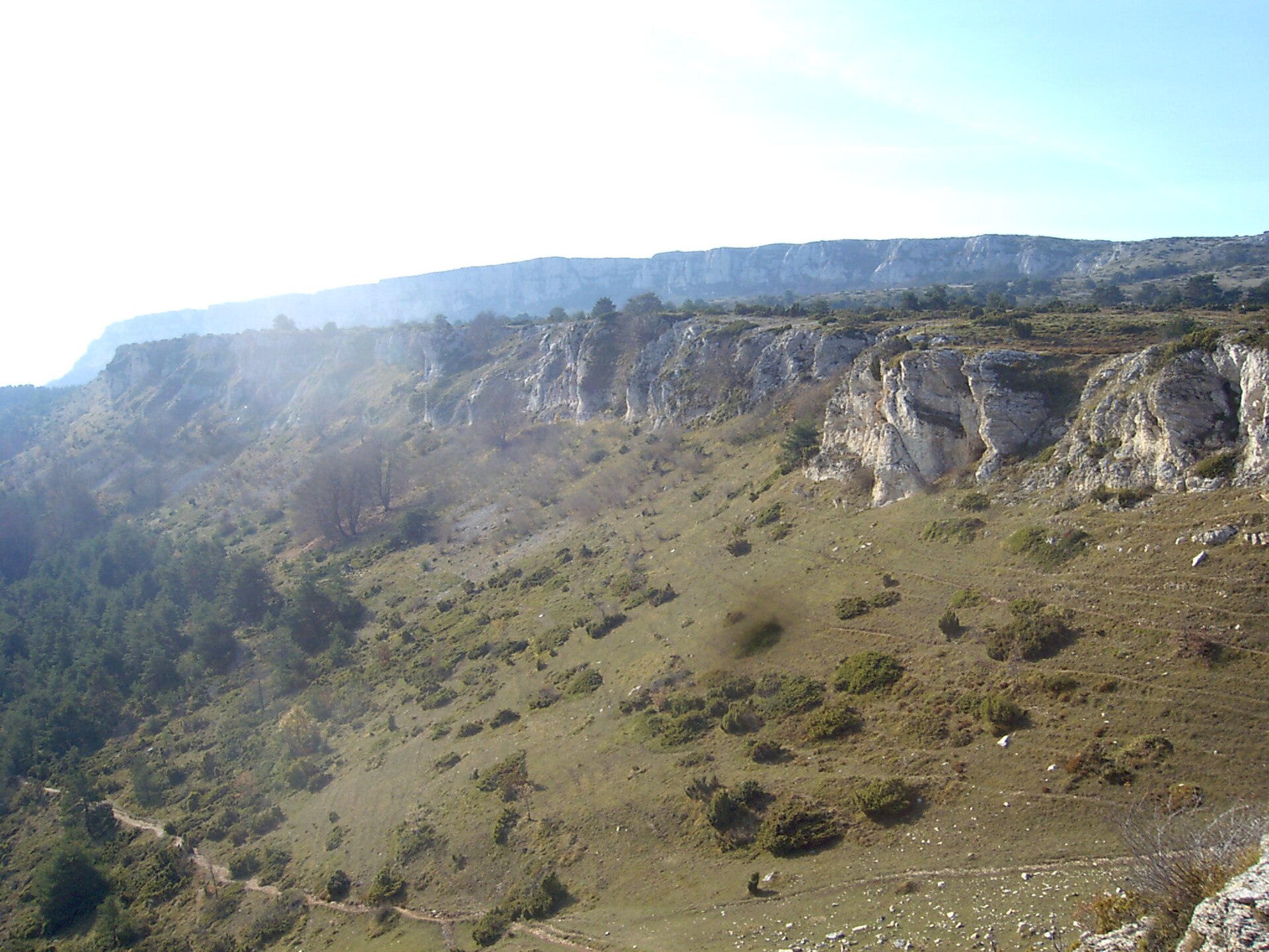
Neila Glacial Lagoons Natural Park
Nature park of 6,860 hectares in Spain, established in 2008.
Overview
Nature park of 6,860 hectares in Spain, established in 2008.
Neila Glacial Lagoons Natural Park is a nature park in Spain (Europe). It is a predominantly terrestrial area. Established on 9 December 2008, it covers about 6,860 hectares.
Protections and designations
Natura 2000 · habitats (SAC)
- Sierra de la Demanda ES4120092
Natura 2000 · birds (SPA)
- Sierra de la Demanda - ZEPA ES4120012
Protected as a nature park. International labels and designations: Natura 2000 network (2 sites). Key dates: first Natura 2000 site under the Birds Directive in 2000, established in 2008 and first Natura 2000 site under the Habitats Directive in 2015.
In our collections
Timeline
-
2000
First Natura 2000 site under the Birds Directive
-
2008
Established
-
2015
First Natura 2000 site under the Habitats Directive
Sources: Wikidata (CC0) for establishment and international labels; EEA Natura 2000 database (CC-BY 4.0) for site designation dates.
Frequently asked questions
Where is Neila Glacial Lagoons Natural Park?
In Spain (Europe). Representative point: 42.0456° N, 3.0556° W.
How large is Neila Glacial Lagoons Natural Park?
About 6,860 hectares (69 km²). It is the 48th largest of the 73 nature parks in Spain covered by Parkavela.
When was Neila Glacial Lagoons Natural Park established?
On 9 December 2008.
What habitats and landscapes does Neila Glacial Lagoons Natural Park include?
A terrestrial area, with forests and mountains.
What rocks lie beneath Neila Glacial Lagoons Natural Park?
According to the European 1:1 million geological map (EGDI), the bedrock consists mainly of conglomerates and breccias (56% of sampled points), limestones (19%) and dolomites (13%). These are mostly sedimentary rocks. The geological units date mainly from the Jurassic (69% of sampled points).
What is the highest point of Neila Glacial Lagoons Natural Park?
Pico de la Laguna, at 2,004 m (OpenStreetMap).
What are the main summits of Neila Glacial Lagoons Natural Park?
Pico de la Laguna (2,004 m), Cumbre Triguera (1,992 m), Peña Triguera (1,955 m), Pico Toscoso (1,913 m) and Peña Aguda (1,909 m) (OpenStreetMap).
Which international labels apply to Neila Glacial Lagoons Natural Park?
Natura 2000 network (2 sites).
When is the best time to visit Neila Glacial Lagoons Natural Park?
Best time to visit: from June to September, with average temperatures of 10 to 15 °C and moderate rainfall.
Is there snow in Neila Glacial Lagoons Natural Park?
Yes. According to NASA's MODIS satellites (2015–2025 average), snow covers the site about 40 days a year, mostly from December to March.
What is there to see in Neila Glacial Lagoons Natural Park?
Cascada del Chorrón (Wikidata).
Are there historic monuments in Neila Glacial Lagoons Natural Park?
Yes. According to Wikidata, 2 monuments listed as Bien de Interés Cultural stand within the boundary. For example: “Iglesia de San Miguel” in Neila and “Rollo de Justicia” in Neila.
What is the nearest large city to Neila Glacial Lagoons Natural Park?
Nearest towns of over 50,000 people, as the crow flies: Logroño (58 km) and Burgos (62 km). Nearest airport: Vitoria (VIT), about 89 km away.
How can I reach Neila Glacial Lagoons Natural Park by train?
The nearest railway station is Barbadillo del Mercado, about 24 km from the site boundary.
Where can I get visitor information on site?
Casa del Parque natural Lagunas Glaciares de Neila.
Are there waymarked hiking trails in Neila Glacial Lagoons Natural Park?
Yes. Waymarked hiking routes listed in OpenStreetMap: 5, including GR 290 (74 km), Senda del Piquillo, Sendero de las Lagunas de Neila and Sendero del Collado de Neila. The “PR-BU 204 · Sendero del Collado de Neila” route runs for about 11 km through the site, with some 320 m of ascent on its longest section.
Which species can be seen in Neila Glacial Lagoons Natural Park?
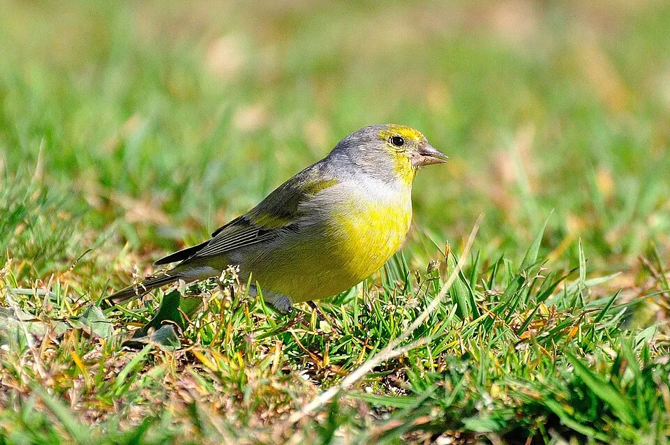
Among the species most often recorded on GBIF are Periparus ater (Coal tit), Gyps fulvus (Griffon Vulture), Fringilla coelebs (Eurasian Chaffinch) and Carduelis citrinella (Citril Finch).
© OpenStreetMap
Download the boundary: GeoJSON · GPX Boundary © OpenStreetMap contributors (ODbL).
Geography
The representative point of the site lies at around 1,876 m above sea level. Over the 1996–2025 period, the mean annual temperature is about 5.5 °C and total precipitation reaches roughly 901 mm per year. The warmest month is usually August, the coolest January, and the wettest November. According to the European 1:1 million geological map (EGDI), the bedrock consists mainly of conglomerates and breccias (56% of sampled points), limestones (19%) and dolomites (13%). These are mostly sedimentary rocks. The geological units date mainly from the Jurassic (69% of sampled points).
Area
- Area
- 6,860 ha
- Elevation
- 1,876 m
- Median elevation
- 1,510 m
- Mean slope
- 18°
- Snow cover
- ≈ 40 days a year
- Coordinates
- 42.0456, -3.0556
Terrain: Mapzen Terrain Tiles (SRTM, USGS)
Elevation bands
- 1,000–1,500 m 48%
- 1,500–2,000 m 51%
- 2,000–2,500 m 1%
share of the site in each elevation band (smoothed terrain model: summits are rounded off) · Terrain: Mapzen Terrain Tiles (SRTM, USGS)
Bedrock
- Conglomerates and breccias 56 %
- Limestones 19 %
- Dolomites 13 %
- Mudstones 6 %
- Sandstones 6 %
Sedimentary rocks 100 % · Main age: Jurassic (69%)
Source: EGDI 1:1M geological map (EuroGeoSurveys and national geological surveys), CC BY 4.0 · 16 sampled points within the site.
Main summits
- Pico de la Laguna2,004 m
- Cumbre Triguera1,992 m
- Peña Triguera1,955 m
- Pico Toscoso1,913 m
- Peña Aguda1,909 m
- Cerro Garañón1,819 m
- Cantincao1,818 m
- Cerro del Fraile1,781 m
- Peña Quemada1,761 m
- La Esculca1,704 m
Data © OpenStreetMap contributors (ODbL)
Climate
● Mean temperature (°C) · ▮ Precipitation (mm)
Source: Copernicus ERA5-Land (C3S, doi:10.24381/cds.68d2bb30), monthly averages 1996–2025 interpolated to the representative point, temperatures adjusted for elevation.
Contains modified Copernicus Climate Change Service information 2026. Neither the European Commission nor ECMWF is responsible for any use that may be made of the Copernicus information or data it contains.
Snow cover measured by satellite
J
F
M
A
M
J
J
A
S
O
N
D
average share of the site under snow · snowiest parts · ≈ 40 days a year
Snow cover: MODIS/Terra MOD10CM v61 (Hall & Riggs, 2021, NASA NSIDC DAAC, doi:10.5067/MODIS/MOD10CM.061), imagery from NASA GIBS (ESDIS); 2015–2025 average, grid of about 5 km.
Natural habitats
According to CORINE Land Cover (2018), the site is mainly made up of forests (63%), grassland and meadows (21%) and heath and scrub (12%). Woodland is mostly coniferous. Elevation ranges from about 1,170 m to 2,004 m (highest point: Pico de la Laguna). Median elevation is 1,510 m, and 52% of the site lies above 1,500 m (SRTM elevation model). The terrain is steep: 63% of slopes exceed 15° (mean slope 18°). The 2 Natura 2000 sites overlapping the area list 35 habitats of European interest (6 priority), the most extensive being Galicio-Portuguese oak woods with Quercus robur and Quercus pyrenaica, European dry heaths and Atlantic acidophilous beech forests with Ilex and sometimes also Taxus in the shrublayer (Quercion robori-petraeae or Ilici-Fagenion).
Biodiversity
Based on occurrences aggregated by GBIF, several species are regularly recorded within the site. Among the most frequent are Periparus ater (Coal tit), Gyps fulvus (Griffon Vulture), Fringilla coelebs (Eurasian Chaffinch) and Carduelis citrinella (Citril Finch). The full list of documented taxa is shown below. The overlapping Natura 2000 sites list 117 species of European interest: 56 birds, 24 mammals, 3 reptiles, 6 amphibians, 4 fish, 10 invertebrates, 13 plants and 1 lichen.
Habitats of European interest
From the official forms of the 2 Natura 2000 sites overlapping the area (areas reported for each whole site).
- Galicio-Portuguese oak woods with Quercus robur and Quercus pyrenaica 17,700 ha
- European dry heaths 9,116 ha
- Atlantic acidophilous beech forests with Ilex and sometimes also Taxus in the shrublayer (Quercion robori-petraeae or Ilici-Fagenion) 7,203 ha
- Alpine and Boreal heaths 1,697 ha
- Species-rich Nardus grasslands, on silicious substrates in mountain areas (and submountain areas in Continental Europe) priority 1,531 ha
- Semi-natural dry grasslands and scrubland facies on calcareous substrates (Festuco-Brometalia) (* important orchid sites) 1,008 ha
- Western Mediterranean and thermophilous scree 895 ha
- Lowland hay meadows (Alopecurus pratensis, Sanguisorba officinalis) 833 ha
and 27 more
Species of European interest
Birds · 56
Eurasian Goshawk (Accipiter gentilis) resident, Common Sandpiper (Actitis hypoleucos) resident, Common Kingfisher (Alcedo atthis) resident, Mallard (Anas platyrhynchos) resident, Tawny Pipit (Anthus campestris) breeding, Meadow Pipit (Anthus pratensis) wintering, Water Pipit (Anthus spinoletta) resident, Golden Eagle (Aquila chrysaetos) resident, Grey Heron (Ardea cinerea) passage, Eurasian Eagle-owl (Bubo bubo) resident, Common Buzzard (Buteo buteo) resident, European Nightjar (Caprimulgus europaeus) breeding and 44 more
Mammals · 24
Barbastelle (Barbastella barbastellus), Grey wolf (Canis lupus), Serotine bat (Eptesicus serotinus), European wildcat (Felis silvestris), Pyrenean desman (Galemys pyrenaicus), Common genet (Genetta genetta), Savi's Pipistrelle (Hypsugo savii), Eurasian otter (Lutra lutra), European Mink (Mustela lutreola), Western Polecat (Mustela putorius), Alcathoe Whiskered Bat (Myotis alcathoe), Bechstein's bat (Myotis bechsteinii) and 12 more
Reptiles · 3
Smooth snake (Coronella austriaca), Western green lizard (Lacerta bilineata), Common wall lizard (Podarcis muralis)
Amphibians · 6
Midwife toad (Alytes obstetricans), Iberian painted frog (Discoglossus galganoi), Natterjack toad (Epidalea calamita), European Treefrog (Hyla molleri), Perez's Frog (Pelophylax perezi), Marbled newt (Triturus marmoratus)
Fish · 4
Bermejuela (Achondrostoma arcasii), Northern Iberian spined-loach (Cobitis calderoni), Luciobarbus bocagei, Northern straight-mouth nase (Pseudochondrostoma duriense)
Invertebrates · 10
White-clawed Crayfish (Austropotamobius pallipes), Greater Capricorn Beetle (Cerambyx cerdo), Southern damselfly (Coenagrion mercuriale), Eastern Eggar (Eriogaster catax), Marsh fritillary (Euphydryas aurinia), Jersey Tiger (Euplagia quadripunctaria), Stag beetle (Lucanus cervus), Dusky Large Blue (Maculinea nausithous), Apollo (Parnassius apollo), Rosalia longicorn (Rosalia alpina)
Plants · 13
Hamatocaulis moss (Hamatocaulis vernicosus), Fir Clubmoss (Huperzia selago), Floating water-plantain (Luronium natans), Marsh clubmoss (Lycopodiella inundata), Stag's-horn Clubmoss (Lycopodium clavatum), Petticoat daffodil (Narcissus bulbocodium), Angel's-tears (Narcissus triandrus), Twisted bog-moss (Sphagnum contortum), Magellan's sphagnum (Sphagnum magellanicum), Olive bog-moss (Sphagnum majus), Sphagnum Mosses (Sphagnum spp.), Sphagnum (Sphagnum squarrosum) and 1 more
Lichens · 1
Cladonia (cladina) subsp.
Source: Natura 2000 standard data forms (EEA, CC-BY 4.0). Not exhaustive: sensitive species are not published.
Species to look out for


Bird
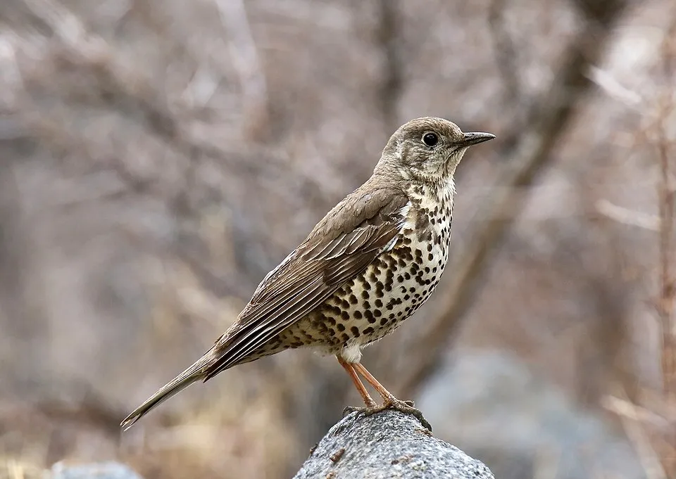
Mistle Thrush
Turdus viscivorus39 records © Imran Shah from Islamabad, Pakistan · CC BY-SA 2.0
Observed species
Occurrences documented via GBIF; they are neither an exhaustive inventory nor proof of current presence.
- Coal tit · Periparus ater · 61
- Griffon Vulture · Gyps fulvus · 47
- Eurasian Chaffinch · Fringilla coelebs · 45
- Citril Finch · Carduelis citrinella · 45
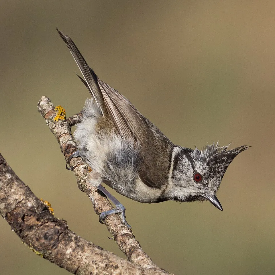
- European Crested Tit · Lophophanes cristatus · 43
- Mistle Thrush · Turdus viscivorus · 39
- Northern Raven · Corvus corax · 38
- Black Redstart · Phoenicurus ochruros · 38
- European robin · Erithacus rubecula · 37
- Common Blackbird · Turdus merula · 34
- Red Crossbill · Loxia curvirostra · 34
- Short-toed Treecreeper · Certhia brachydactyla · 33
+18 more species
- Goldcrest · Regulus regulus · 32
- Eurasian Crag Martin · Ptyonoprogne rupestris · 30
- Great Spotted Woodpecker · Dendrocopos major · 27
- Eurasian Jay · Garrulus glandarius · 27
- Common Firecrest · Regulus ignicapilla · 26
- Wild boar · Sus scrofa · 25
- Dunnock · Prunella modularis · 23
- Cinereous Vulture · Aegypius monachus · 22
- Bogbean · Menyanthes trifoliata · 22
- Mallard · Anas platyrhynchos · 22
- Red deer · Cervus elaphus · 21
- Great tit · Parus major · 21
- Iberian Woodpecker · Picus sharpei · 20
- Rock Bunting · Emberiza cia · 17
- Carrion crow · Corvus corone · 17
- Digger small dung beetle · Teuchestes fossor · 16
- Water Pipit · Anthus spinoletta · 16
- Common dung beetle · Aphodius fimetarius · 15
Records: GBIF.org (CC-BY). Names: Wikidata (CC0), GBIF. Photos: Wikimedia Commons.
Conservation challenges
The primary purpose of the site is to preserve its natural habitats and the biodiversity they support. The species recorded (Biodiversity tab) reflect its ecological value. The designations it holds frame its management and the control of land use.
According to Global Forest Change data (University of Maryland, Global Forest Watch), about 313 ha of tree cover were lost within the boundary between 2001 and 2023 (5% of its area), peaking in 2018 and 2020. These losses include logging, storms and fires, and do not account for regrowth. According to CORINE Land Cover, land cover here remained almost unchanged between 1990 and 2018 (less than 0.5% of the area affected). At night, 1% of the area gives off artificial light detectable from space (NASA VIIRS Black Marble composite, 2016). According to the Natura 2000 forms, of 35 assessed habitats of European interest, 1 is in excellent condition and 1 in average or reduced condition. According to the Water Framework Directive assessment (2022 river basin management plans, data 2018), the only river assessed within the site has good ecological status.
Pressure indicators
Tree cover lost
313 ha
2001–2023 · 5% of the area
20012023
Fires since 2016
0
No large fire mapped (fires over about 30 ha)
Light at night
1%
of the area gives off artificial light visible from space
DarkLit
Land cover change
< 0.5%
of the area changed, 1990–2018 · CORINE
Rivers and lakes
100%
of the 15 km of assessed rivers in good or high ecological status · WFD 2022
assessments 2018
Sources: Global Forest Change (Hansen et al., University of Maryland, via Global Forest Watch, CC-BY 4.0); EFFIS, European Commission / Copernicus; NASA Black Marble 2016 (public domain); CORINE Land Cover 2018 (Copernicus) or MODIS.
CORINE Land Cover Change 1990–2018: generated using European Union's Copernicus Land Monitoring Service information (EEA), aggregated by Parkavela; DOI 10.2909/f30f1000-7cf8-43bb-872c-5eb093911b24.
Ecological status of water bodies: European Environment Agency, WISE – Water Framework Directive, 3rd river basin management plans (2022), CC BY 4.0. Official national classification, not comparable between countries.
Practical information
Cities and airport
- Logroño
58 km as the crow flies - Burgos
62 km as the crow flies - Airport: Vitoria (VIT)
89 km as the crow flies
Visitor information
- Casa del Parque natural Lagunas Glaciares de Neila
within the site
Hiking
5 waymarked routes listed, including:
GR 290 (74 km)Senda del PiquilloSendero de las Lagunas de NeilaSendero del Collado de NeilaSendero de las Nilsas de Neila
By bike
+ 4 local loops
Signed cycle routes: this does not mean that cycling is allowed on footpaths.
Wheelchair access
- Casa del Parque natural Lagunas Glaciares de Neila
visitor information
Reported by OpenStreetMap contributors (ODbL); check with the park before visiting.
Data © OpenStreetMap contributors (ODbL) · Wikidata (CC0)
Routes © OpenStreetMap contributors (ODbL), via Waymarked Trails
Waymarked hiking routes
PR-BU 203 Sendero de las Lagunas de Neila
4 km within the site ↗ 193 m↘ 201 m 1,673–1,874 m
PR-BU 204 Sendero del Collado de Neila
10.7 km within the site ↗ 317 m↘ 314 m 1,169–1,433 m
Tracks © OpenStreetMap contributors (ODbL), clipped to the boundary; elevation gain and profiles computed on the longest section from Mapzen Terrain Tiles (≈ 30 m), indicative only.
Access and visiting
The nearest railway station is Barbadillo del Mercado, about 24 km from the site boundary. Nearest towns of over 50,000 people, as the crow flies: Logroño (58 km) and Burgos (62 km). Nearest airport: Vitoria (VIT), about 89 km away. About 12,000 people live within 20 km of the site boundary, 5,800 of them within 10 km; some 170 people are estimated to live inside (GHSL estimate, 2020). This population has fallen by about 6% since 2000. Visitor information on site: Casa del Parque natural Lagunas Glaciares de Neila. Waymarked hiking routes listed in OpenStreetMap: 5, including GR 290 (74 km), Senda del Piquillo, Sendero de las Lagunas de Neila and Sendero del Collado de Neila. OpenStreetMap contributors list one wheelchair-accessible place: Casa del Parque natural Lagunas Glaciares de Neila; check with the park before visiting. To see: Cascada del Chorrón. To plan a visit (access, opening periods, visitor rules), it is best to consult the official information from the managing body and the official website listed in this page's sources.
Source: OpenStreetMap (ODbL), Wikidata (CC0), October 2026.
Built heritage
According to Wikidata, 2 monuments listed as Bien de Interés Cultural stand within the boundary. Examples include “Iglesia de San Miguel” in Neila and “Rollo de Justicia” in Neila.
-
Iglesia de San Miguel
Neila -
Rollo de Justicia
Neila
Source: Wikidata (CC0), monuments in each country’s official heritage protection registers, at national or regional level. Each item links to its Wikidata entry.
When to visit
Best time to visit: from June to September, with average temperatures of 10 to 15 °C and moderate rainfall. Average temperatures drop below 0 °C from December to February: frost is common. These averages apply to the site's representative point (1,876 m); higher up it is markedly cooler and snow lasts longer. According to NASA's MODIS satellites (2015–2025 average), snow covers the site about 40 days a year, mostly from December to March. Day length ranges from about 9 h 07 min in December to 15 h 14 min in June. Wildlife records published on GBIF peak for birds (August), plants (July and August) and butterflies and moths (July and August). These peaks also reflect when observers are most active.
Source: Copernicus ERA5-Land (C3S), monthly averages 1996–2025 at the representative point, temperatures adjusted for elevation.
Contains modified Copernicus Climate Change Service information 2026. Neither the European Commission nor ECMWF is responsible for any use that may be made of the Copernicus information or data it contains.
Wildlife records calendar
JFMAMJJASOND
Birds
Plants
Butterflies & moths
Monthly records published on GBIF (CC-BY), relative to the busiest month; also reflects observer activity.
Gallery
© Rohappy458 · CC BY-SA 4.0
© Gafotas · Public domain
© Valdoria · Public domain
© LBM1948 · CC BY-SA 4.0
© Batoneila · CC BY-SA 4.0
© Rohappy458 · CC BY-SA 4.0
Sources and licences
- Wikidata: Q8537947
- OpenStreetMap: relation 2888445
- Wikipedia: fr.wikipedia.org/wiki/Parc_naturel_des_lacs_glaciaires_de_Neila
References
- cds.climate.copernicus.eu: climate · CC-BY-4.0
- registry.opendata.aws: elevation of the reference point, detailed relief · PD
- land.copernicus.eu: land cover, land cover change, sea share · COPERNICUS
- doi.org: population around the site · CC-BY-4.0
- wikidata.org: official area, establishment date, protected heritage, official name, nearby cities and airport, access and peaks, lake depths, places to see · CC0-1.0
- eea.europa.eu: bathing water quality, ecological status of waters · CC-BY-4.0
- en.eurovelo.com: EuroVelo cycle routes · ODbL-1.0
- cycling.waymarkedtrails.org: cycle routes · ODbL-1.0
- opentopodata.org: elevations · PD
- forest-fire.emergency.copernicus.eu: wildfires · COPERNICUS
- globalforestwatch.org: tree cover loss · CC-BY-4.0
- gbif.org: seasonality of sightings, invasive alien species, observed species · CC-BY-4.0
- europe-geology.eu: geology · CC-BY-4.0
- hydrosheds.org: lakes · CC-BY-4.0
- natura2000.eea.europa.eu: Natura 2000 habitats and species · CC-BY-4.0
- earthobservatory.nasa.gov: night light · PD
- openstreetmap.org: access and peaks, wheelchair access · ODbL-1.0
- hiking.waymarkedtrails.org: route difficulty · ODbL-1.0
- nsidc.org: snow cover · PD
- wikidata.org: Wikipedia article · CC-BY-SA-4.0
Data © OpenStreetMap contributors (ODbL), Wikidata (CC0) and the sources cited.